This has been an amazing trip. We travelled off interstate as much as possible and as a consequence there was very limited wifi or cell service available so I'll be updating my posts one day at a time now that we're home.
My post for Sunday June 19 has now been updated with captions and more pictures - check it out.
Posts up to Saturday June 25 have also been updated.
Thanks for following our travels and for your prayers.
Brad
The post for Sunday June 26 was updated last night.
Monday, July 4, 2011
Friday, July 1, 2011
Sunday June 26 (updated July 12)
Bonners Ferry, Idaho to Flathead Lake, Montana

The hot shower feels so good!
Breakfast is delicious and the morning is sunny and warm - what a great day!
Breakfast is delicious and the morning is sunny and warm - what a great day!

You're right Dad, this sure beats sweeping out the tent
 Anyone for a game of chess?
or a little relaxation by the little blue lake?

After only a few miles we're at the Montana state line

we lose an hour moving into mountain time

The Burlington Northern-Santa Fe rolls through this valley between the highway and the river


real-life cowboys.... uh..... cowgirls


a work of art


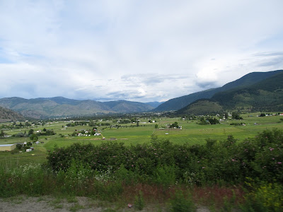
Kalispell Montana looking at Glacier National Park


the 'Going-To-The-Sun' road follows the shore of Lake McDonald to Logan Pass.
The road is only open for the 16 miles to Avalanche Creek and crews are still removing up to 50 feet of snow on the road in Logan Pass! We see dump trucks of snow coming down the mountain.
The road is only open for the 16 miles to Avalanche Creek and crews are still removing up to 50 feet of snow on the road in Logan Pass! We see dump trucks of snow coming down the mountain.


McDonald Creek


ok... if we follow this road we can camp here or maybe here...


Flathead Lake, Montana but...

...no fires allowed

Setting up camp at Flathead State Park, Flathead Lake, Montana; south of Kalispell
This memorial is near our campsite

Mt. Cleveland, at 10,479 ft is the highest peak in Glacier Nat'l Park.
These men attempted the first winter ascent of the mountain and got within 600 feet of the summit when an avalanche swept them away.

Flathead Lake
Saturday June 25 (updated July 9)
Kamloops, BC to Bonners Ferry, Idaho


 Time to put on the rain gear and stow the cameras.


and continues into a poplar grove...


Saturday morning we make breakfast, pack up camp, and head south on highway 5...

riding through rolling hills...

by homes and farms, past...

and...

present,

places of worship...

and places of work.

There's a very active forestry industry here but this place just might be a toothpick factory for Sasquatch.

The day started cool and overcast and it soon became evident we were heading into rain.
 Time to put on the rain gear and stow the cameras.
Several miles south of Merritt on highway 5A the rain has let up and I notice to my right a black animal moving rapidly through the brush on an intercept course with Bob who is a little ways ahead of me.
Hmmm... too big to be a dog or a calf... too small for a cow...
IT'S A BEAR!
I squeeze the radio push-to-talk button and alert Bob - "BEAR! BEAR! 2 O'CLOCK!"
He's stopping but still doesn't see it. The bear is not slowing or changing course. Now we're stopped but from my vantage point it looks like the bear wants some of Bob. All 3 of us are frantically tearing off gloves and digging for cameras. The bear is closing fast... straight for Bob.
The bear runs across the road about 25 yards ahead of Bob.
We finally get shots off just as the bear reaches the left side of the road...


and continues into a poplar grove...


he stops to let us to get a better shot.
Well that sure was exciting!
If I'd only I had a water-proof camera...

switch backs...

and twisties...

Abandoned gold mines cling precariously to the steep mountainside in Hedley, BC.

Riding into more rain.
We'll have our rain gear on & off 4 times today.
We'll have our rain gear on & off 4 times today.

The little town of Osoyoos appears suddenly as we crest a hill.
This is the southern end of the Okanagan Valley - known for dry sunny climate, tourism, orchards, vinyards and several lakes; Swan, Okanagan, Kalamalka, Wood, Skaha, Vaseaux, Tuc-el-Nuit and Osoyoos Lakes make this valley a water-sports playground.
I spent many summers of my youth in this valley.
This is the southern end of the Okanagan Valley - known for dry sunny climate, tourism, orchards, vinyards and several lakes; Swan, Okanagan, Kalamalka, Wood, Skaha, Vaseaux, Tuc-el-Nuit and Osoyoos Lakes make this valley a water-sports playground.
I spent many summers of my youth in this valley.

Looking down on the town of Osoyoos and Osoyoos Lake. Haynes Point can be seen on the right as it almost bisects Osoyoos Lake. The lake is shallow and gets nicely warm in the summer making it ideal for a variety of water sports.
We continue riding east on the Crowsnest Highway into the Kettle Valley and through several small towns; Bridesville, Rock Creek, Midway, Boundary Falls, Anaconda, Greenwood, Grand Forks, Castlegar, Salmo and Creston.
 Anaconda owed its existence to the now defunct Anaconda Copper Mine.
With only a few residents remaining, it is essentially a ghost town serving only as a food and fuel stop for travelers.


beautiful Christina Lake


 Rebecca captures a shot of where we've been

 Our day never gets very warm but this is just about the coldest temp we see today.
 At the summit of Kootenay Pass (1775m, 5823ft) the small lake is still frozen over

and a warning to truckers.
 The sun breaks through dark clouds to highlight this bridge as we approach Creston
 and we're blessed with a double rainbow.


 The sun is setting as we approach Bonners Ferry, soon we'll be off the road for the night...
We stop for provisions at a grocery store and I try for wifi from the parking lot - woo-hoo, success! A quick google search turns up Blue Lake Campground with a phone number. James gives me directions and we're on our way. He gives us a good deal on a site for the night and asks if we would like to buy any firewood. No thanks - we're tired, hungry and ready for bed.
"You guys must be a little chilled - get set up and I'll bring a few pieces of wood and my torch, no charge."

James is a great host. Now THAT is a fast way to start a campfire!
Soon we're warm & fed.
Good night all
We continue riding east on the Crowsnest Highway into the Kettle Valley and through several small towns; Bridesville, Rock Creek, Midway, Boundary Falls, Anaconda, Greenwood, Grand Forks, Castlegar, Salmo and Creston.

With only a few residents remaining, it is essentially a ghost town serving only as a food and fuel stop for travelers.


Down the mountain into the town of Grand Forks

The sign reads: "Please! Avoid use of engine brakes in urban areas"
This is an 'Urban area'?????

beautiful Christina Lake

The rain starts so abruptly there is a defined dry/wet line on the road.


and soon we're rewarded with a rainbow


and a warning to truckers.


The border-crossing south of Creston into Idaho goes smoothly.
Yes - they let me back in!


We stop for provisions at a grocery store and I try for wifi from the parking lot - woo-hoo, success! A quick google search turns up Blue Lake Campground with a phone number. James gives me directions and we're on our way. He gives us a good deal on a site for the night and asks if we would like to buy any firewood. No thanks - we're tired, hungry and ready for bed.
"You guys must be a little chilled - get set up and I'll bring a few pieces of wood and my torch, no charge."

James is a great host. Now THAT is a fast way to start a campfire!
Soon we're warm & fed.
Good night all
Subscribe to:
Comments (Atom)